Scottyland Camping Private
Private RV park, listed in OpenStreetMap, Pennsylvania.
Summary
Located about 52 miles (straight line) from Pittsburgh, Scottyland Camping is a private RV park. OpenStreetMap records no hookups or amenities for this RV park, so check its website before you go; 2 public dump stations are mapped within 25 miles. Within 5 miles there are 1.2 miles of trail open to bikes, the closest being Lake Trail (3.1 mi away).
Hookups & amenities
- 🚿ShowersNot listed
- 🚻ToiletsNot listed
- 🚰Drinking waterNot listed
- ⚡Electric hookupsNot listed
- 💧Water hookupsNot listed
- 🔧Sewer hookupsNot listed
- 🔌Full hookups (E/W/S)Not listed
- 🚐Dump stationNot listed
- 📶Wi-FiNot listed
- 🧺LaundryNot listed
- 🏪Camp storeNot listed
- 🛝PlaygroundNot listed
- 🏊SwimmingNot listed
- 🚤Boat rampNot listed
- 🐕Pet-friendlyNot listed
- ♿ADA-accessible sitesNot listed
- 🛖CabinsNot listed
- 🔥Fire ringsNot listed
- 🍖GrillsNot listed
- 🪑Picnic tablesNot listed
- 🧑Camp hostNot listed
- 🐻Food storage lockersNot listed
Listed only when OpenStreetMap report it. "Not listed" means the source doesn't say, not that the campground lacks it.
RV details from OpenStreetMap
OpenStreetMap has only this park's name and location: no hookup, amperage, length, dump or Wi-Fi tags.
Map: trails and roads near Scottyland Camping
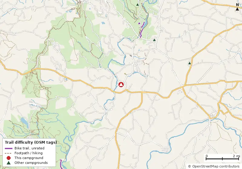
Loads MapLibre with OpenFreeMap tiles only when you tap.
How it compares
- There are 20 other campgrounds in our data within 25 miles.
- Straight-line distance: Pittsburgh ~52 mi, Winchester ~79 mi, Harrisonburg ~105 mi.
Amenities & rules
The agency hasn't published an amenity list for this campground.RVs/trailers
Trails within 5 miles
No named Forest Service or National Park Service trails are mapped within 5 miles. Trails on state, county or Corps of Engineers land aren't in these datasets.
Mountain biking nearby
1.2 miles of bike-legal trail lie within 5 miles. Difficulty mix: Unrated: 1.2 mi
| Trail | Closest point | Miles within 5 mi | Difficulty (as tagged) | Kids | Source |
|---|---|---|---|---|---|
| Lake Trail | 3.1 mi | 0.6 | Unrated | OSM | |
| Copper Kettle Trail | 3.7 mi | 0.4 | Unrated | OSM | |
| path thru fields | 3.9 mi | 0.2 | Unrated | OSM |
Ratings come only from OpenStreetMap mtb:scale / IMBA tags. Untagged trails show as "Unrated", and we never guess. Check conditions and maps on Trailforks or MTB Project.
Dump stations near Scottyland Camping
| Public dump station (OpenStreetMap) | Distance | Fee | Water | Access |
|---|---|---|---|---|
| Dump station (unnamed in OSM) | 3.5 mi | Not listed | Not listed | Not listed |
| Dump station (unnamed in OSM) | 11.1 mi | Not listed | Not listed | Not listed |
Nearby campgrounds with an on-site dump station: Lost Mountain Campground (3.4 mi), Hickory Hollow Campground (4.4 mi), Mountain Pines Campground (9.9 mi), Rainbow Woods Campground (17.5 mi). Many limit dumping to registered guests.
Straight-line distances. Dump station points: © OpenStreetMap contributors (ODbL); fees, hours and access change, so confirm before you go.
Nearest campgrounds
| Campground | Miles | State | Fee/night | Sites | Hookups | Max RV | Pets | Booking | Trails ≤5 mi |
|---|---|---|---|---|---|---|---|---|---|
| Lost Mountain Campground Cabins Private campground |
3.4 | PA | — | — | E | yes | — | ? | 0 |
| Hickory Hollow Campground Cabins Private campground |
4.4 | PA | — | — | E | yes | — | ? | 0 |
| Laurel Hill State Park Campground Laurel Hill State Park |
5.0 | PA | From $16 (PA schedule) | — | E W S | yes | — | Reserve | 0 |
| Kooser State Park Campground Kooser State Park |
8.1 | PA | From $16 (PA schedule) | — | E W S | yes | — | Reserve | 0 |
| Mountain Pines Campground Cabins Private campground |
9.9 | PA | — | — | E | yes | — | ? | 0 |
| Paddler's Lane Campground Private campground |
10.2 | PA | — | — | — | — | — | ? | 0 |
Hookups: E = electric (max amps), W = water, S = sewer. "—" means the agency doesn't publish it. Trail counts are named USFS/NPS trails within 5 miles. 🟢 = kid-friendly (green-rated) bike trail nearby.