Salt Springs Recreation Area
USDA Forest Service campground in National Forests in Florida, near Ft. McCoy, Florida.
Summary
Managed by the USDA Forest Service, Salt Springs Recreation Area sits in National Forests in Florida, about 60 miles (straight line) from Orlando. The campground lists 146 overnight sites (including 94 electric sites and 52 tent-only sites). Within 5 miles there are 13.6 miles of trail open to bikes, the closest being Salt Springs Connector (0.3 mi away). RVs and trailers up to 40 ft can fit, and sites are reservable on Recreation.gov, with full hookups available.
When to book: Recreation.gov's default: most campsites open 6 months before arrival, at 10 a.m. ET, but each campground can set its own window (check its Seasons and Fees tab). Example: Memorial Day weekend 2027 (arrive Fri, May 28, 2027): booking opens Sat, Nov 28, 2026, at 10 a.m. ET. Source: Recreation.gov: Tips for making campsite reservations at popular locations. Campsite booking-date calculator →
When it's open
Season not listed
Florida campgrounds open year-round →
Neither Recreation.gov nor our other sources publish an open season for this campground, so we don't guess. Check the official listing before an off-season trip.
Hookups & amenities
- 🚿ShowersNot listed
- 🚻ToiletsNot listed
- 🚰Drinking waterNot listed
- ⚡Electric hookups (50 amp)Listed
- 💧Water hookupsListed
- 🔧Sewer hookupsListed
- 🔌Full hookups (E/W/S)Listed
- 🚐Dump stationNot listed
- 📶Wi-FiNot listed
- 🧺LaundryNot listed
- 🏪Camp storeNot listed
- 🛝PlaygroundNot listed
- 🏊SwimmingNot listed
- 🚤Boat rampNot listed
- 🐕Pet-friendlyListed
- ♿ADA-accessible sitesListed
- 🛖CabinsNot listed
- 🔥Fire ringsNot listed
- 🍖GrillsListed
- 🪑Picnic tablesListed
- 🧑Camp hostNot listed
- 🐻Food storage lockersNot listed
Listed only when Recreation.gov site records report it. "Not listed" means the source doesn't say, not that the campground lacks it.
Map: trails and roads near Salt Springs Recreation Area
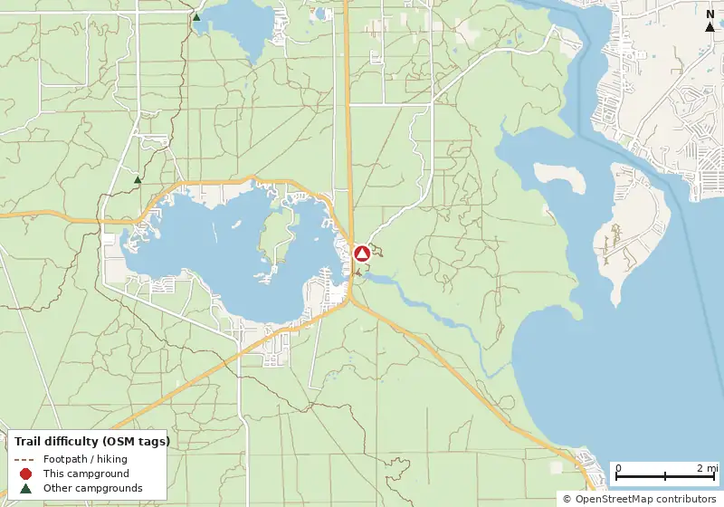
Loads MapLibre with OpenFreeMap tiles only when you tap.
Campsite layout
Check live availability on Recreation.gov ↗
We don't show live availability. Openings change by the minute and only the official reservation system has them.
How it compares
- With 146 sites it is the #7 largest of 94 Florida campgrounds that publish a site count.
- There are 21 other campgrounds in our data within 25 miles.
- 80% of Florida campgrounds that publish a length limit accept a rig this long (40 ft).
- Electric sites go up to 50 amp service (94 electric sites).
- 75% of sites with a shade rating are listed as shaded or partly shaded.
- Pets allowed on 146 of 146 sites; campfires allowed on 146 (subject to seasonal fire bans).
- Straight-line distance: Orlando ~60 mi, Jacksonville ~68 mi, Tampa ~107 mi.
Site mix
Amenities & rules
GrillsPicnic tablesPets allowedTentsRVs/trailers5 accessible sites
Trails near Salt Springs Recreation Area
| Trail | Closest point | Mapped miles within 5 mi | Source |
|---|---|---|---|
| Bear Swamp Trail | 0.0 mi | 1.3 | USFS |
| Salt Springs Connector | 0.3 mi | 4.9 | USFS |
| Salt Springs Spur Trail | 0.7 mi | 2.7 | USFS |
| Salt Springs Wildlife Viewing | 1.2 mi | 1.4 | USFS |
| Fnst - Lake George Section | 3.1 mi | 11.9 | USFS |
| Longleaf Trail | 3.1 mi | 5.2 | USFS |
| 0224-D | 3.5 mi | 2.2 | USFS |
| 0224-F | 4.4 mi | 0.7 | USFS |
| Longleaf Spur | 4.7 mi | 0.6 | USFS |
Mountain biking nearby
13.6 miles of bike-legal trail lie within 5 miles. Difficulty mix: Unrated: 13.6 mi
| Trail | Closest point | Miles within 5 mi | Difficulty (as tagged) | Kids | Source |
|---|---|---|---|---|---|
| Salt Springs Connector | 0.3 mi | 4.9 | Unrated | USFS | |
| Longleaf Trail | 3.1 mi | 5.2 | Unrated | USFS | |
| 0224-D | 3.5 mi | 2.2 | Unrated | USFS | |
| 0224-F | 4.4 mi | 0.7 | Unrated | USFS | |
| Longleaf Spur | 4.7 mi | 0.6 | Unrated | USFS |
Trails marked OSM: © OpenStreetMap contributors (ODbL). Ratings come only from OpenStreetMap mtb:scale / IMBA tags. Untagged trails show as "Unrated", and we never guess. Check conditions and maps on Trailforks or MTB Project.
Dump stations near Salt Springs Recreation Area
| Public dump station (OpenStreetMap) | Distance | Fee | Water | Access |
|---|---|---|---|---|
| Dump station (unnamed in OSM) | 0.2 mi | Not listed | Not listed | Not listed |
| Dump station (unnamed in OSM) | 21.3 mi | Free | Not listed | Customers |
Straight-line distances. Dump station points: © OpenStreetMap contributors (ODbL); fees, hours and access change, so confirm before you go.
Activities listed
BoatingCampingCanoeingFishingHikingSwimming Site
Nearest campgrounds
| Campground | Miles | State | Fee/night | Sites | Hookups | Max RV | Pets | Booking | Trails ≤5 mi |
|---|---|---|---|---|---|---|---|---|---|
| Grassy pond Ocala National Forest |
4.8 | FL | Free | — | — | — | — | ? | 30 (88.0 mi) |
| Lake Delancy West Campground National Forests in Florida |
5.9 | FL | — | 120 | — | — | yes | Reserve | 34 (99.6 mi) |
| Hopkins Prairie Campground National Forests in Florida |
6.6 | FL | — | 20 | — | yes | yes | Reserve | 5 (20.7 mi) |
| Davenport Landing Ocala National Forest |
8.4 | FL | Free | 5 | — | — | — | ? | 30 (70.5 mi) |
| Lake Eaton Campground National Forests in Florida |
10.7 | FL | — | 14 | — | — | yes | Reserve | 4 (33.5 mi) |
| Marjorie Harris Carr Cross Florida Greenways State Recreation and Conservation Area Campground Marjorie Harris Carr Cross Florida Greenways State Recreation and Conservation Area |
12.0 | FL | $16–$42 (FL schedule) | 156 | E 50A W S | yes | — | Reserve | 15 (32.0 mi) |
Hookups: E = electric (max amps), W = water, S = sewer. "—" means the agency doesn't publish it. Trail counts are named USFS/NPS trails within 5 miles. 🟢 = kid-friendly (green-rated) bike trail nearby. "Open year-round" and month ranges come from the agency, state park or OpenStreetMap season; no tag means no season is published.